Live Situation: Cyclone Gezani Impacting Southern and Central Mozambique
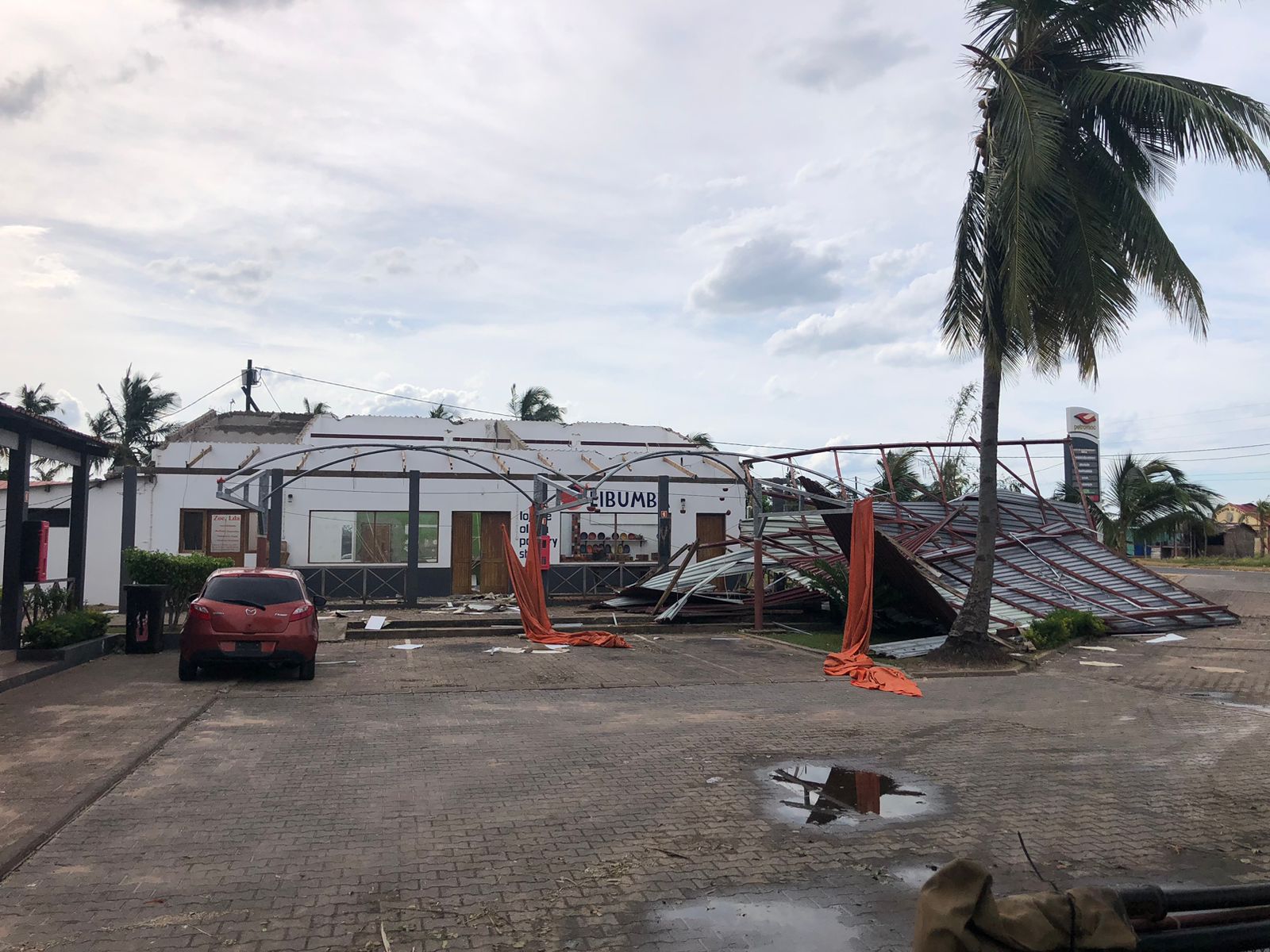
Cyclone Gezani has moved across the Mozambique Channel and is now directly impacting parts of southern and central Mozambique with sustained heavy rainfall, strong winds, and widespread flooding. Over the past 48 hours, river systems in low-lying provinces have surged, road networks have been compromised, and emergency services have shifted into active response mode.
Meteorological tracking shows the system weakening slightly inland but continuing to generate intense rainfall bands across already saturated districts. Flood levels remain high in several river basins, and secondary roads are reporting washouts and structural damage.
This is not a uniform national event. Impact remains geographically concentrated, but in affected provinces the disruption is severe.
Improved regional flights, better road links, and streamlined visa processes have made multi-country travel easier than ever. From the traveller’s perspective, these journeys feel seamless. Transfers are organised in advance, borders are crossed smoothly, and the experience unfolds as one continuous adventure rather than a series of separate trips.
What is less obvious is how safety responsibility changes once a border is crossed.
What Has Changed in the Last 48 Hours
Over the past two days:
- River levels in southern basins have exceeded warning thresholds
- Sections of the EN1 highway have reported flooding and structural damage
- Domestic transport routes have experienced rerouting and delays
- Power interruptions have been reported in smaller towns
- Emergency response teams have been deployed to flood-affected communities
Heavy rainfall has compounded pre-existing flood stress from earlier seasonal storms. In some areas, water has not had time to recede before additional bands of rain arrived.
Authorities are prioritising humanitarian access and damage assessment.

Most Affected Provinces and Districts
Current impact concentration includes:
Southern Provinces
Gaza Province has experienced widespread flooding near river systems, particularly in low-lying districts. Road access has been partially disrupted.
Maputo Province
Certain rural and peri-urban districts are reporting water accumulation and transport interruption.
Inhambane Corridor
Heavy rainfall and coastal wind exposure have affected sections of road infrastructure. Beach zones are experiencing rough sea conditions and marine activity suspension.
Central River Basins
Flooding has been reported in areas downstream of major rivers where water runoff accumulates.
Northern provinces at this stage are experiencing rainfall but are not reporting the same degree of structural damage.
Infrastructure Strain: Roads, Bridges and Transport
Flood events in Mozambique typically impact infrastructure in predictable ways:
Primary Highways
Major highways such as EN1 are vulnerable where culverts and bridges cross floodplains. Temporary closures or lane restrictions are being implemented in affected sections.
Secondary Roads
Gravel and rural roads are particularly exposed. Washouts create hazardous conditions even after water begins to recede.
Air Transport
Major airports remain operational with weather-related delays. Smaller regional airstrips may experience intermittent closures due to waterlogged runways or reduced visibility.
Marine Transfers
Coastal swell and strong currents have led to suspension of boat transfers in some districts.
The greatest immediate travel risk is overland movement through partially flooded corridors.

Health Risk Escalation After Flood Events
Flood conditions introduce secondary health risks that extend beyond immediate storm exposure.
Malaria Risk
Standing water significantly increases mosquito breeding. Transmission risk often rises in the weeks following heavy flooding.
Water Contamination
Compromised sanitation systems elevate the risk of gastrointestinal illness.
Cholera and Diarrhoeal Disease
Outbreak monitoring typically intensifies after major flood events.
Heat and Dehydration
High humidity following storms can increase physical stress.
Anyone experiencing fever in the coming days should seek immediate testing.
Cyclone Gezani Forecast: What Happens Next
Meteorological projections indicate that Cyclone Gezani is expected to weaken further as it moves inland, but residual rainfall bands may persist for several days. Even after wind intensity drops, floodwaters can continue rising downstream as runoff accumulates.
Key risks in the next 72 hours include:
- Delayed river cresting in downstream districts
- Additional road collapse in saturated areas
- Landslides in erosion-prone corridors
- Renewed marine hazards along exposed coastline
Weather systems in the Mozambique Channel remain active during this seasonal window, meaning additional disturbances cannot be ruled out.

Is Mozambique Fully Closed to Travel?
No.
Mozambique is not uniformly closed. Impact remains regional. However, certain corridors and districts are experiencing severe disruption.
The critical variable is location.
A flooded river basin in one province does not automatically mean coastal resorts hundreds of kilometers away are inaccessible. However, overland routes connecting them may be temporarily compromised.
Real-time confirmation of route viability is essential before any movement.
Immediate Risk Assessment for Travellers
If you are currently in Mozambique:
- Avoid driving through flooded roads
- Do not attempt to cross moving water
- Remain indoors during peak wind periods
- Monitor official meteorological updates
- Confirm transfer status before departure
If you are planning travel within the next week:
- Confirm airport and transfer operations directly
- Avoid self-drive through affected provinces
- Build schedule flexibility
- Prepare for rerouting
The most dangerous behaviour during flood conditions is assumption.
Why Real-Time Emergency Coordination Is Critical During Cyclones
Cyclone and flood conditions create unpredictability.
Road closures shift hourly. Medical facilities may be overwhelmed. Local emergency numbers may not respond quickly in saturated districts.
During this type of weather disruption, response time determines severity.
Real-time emergency coordination provides:
- Immediate geolocation
- Rapid contact with responders
- Medical facility verification
- Rerouting support
- Communication with next of kin
In unstable infrastructure environments, clarity and speed reduce escalation.

Media Headlines vs Ground Reality
Global coverage often frames events as nationwide catastrophe. While humanitarian impact is serious in affected districts, the operational status of tourism corridors differs.
The distinction between:
Humanitarian disaster zones and Operational tourism corridors must be assessed in real time.
Decisions based solely on international headlines may not reflect province-level reality.
What This Means for the Next 5 Days
Over the coming days:
- River levels will determine the duration of road disruption
- Damage assessments will clarify infrastructure stability
- Marine activity will resume gradually as swell subsides
- Air transport will stabilise once rainfall intensity reduces
The critical period is the next 72 hours. After that, recovery trajectory becomes clearer.
Final Intelligence Summary
Cyclone Gezani has delivered significant rainfall and flooding to parts of Mozambique, particularly southern and central provinces. Infrastructure strain is real in affected districts. Health risk increases in the post-flood window.
However, impact remains regionally concentrated.
Mozambique is not uniformly inaccessible, but travel through flood-affected corridors requires verification and caution.
The immediate priority is accurate, province-level intelligence and real-time coordination in case conditions shift.
Weather cannot be controlled.
Response speed can.
FAQs: Cyclone Gezani Mozambique
Is Cyclone Gezani still active over Mozambique?
Cyclone Gezani has weakened inland but continues to generate heavy rainfall across parts of southern and central Mozambique. Residual rain bands are contributing to ongoing flood risk even as wind intensity decreases. Monitoring official meteorological updates over the next 72 hours is critical as river systems may continue rising downstream.
Which areas of Mozambique are worst affected right now?
Southern provinces, particularly low-lying districts near major river basins, are experiencing the most severe flooding. Sections of major highways and rural roads have been compromised. Northern provinces are seeing rainfall but not the same structural damage levels at this stage. Impact remains regionally concentrated rather than nationwide.
Are flights to Mozambique cancelled because of Cyclone Gezani?
Major international airports remain operational, though delays may occur due to weather conditions. Smaller regional airstrips may face intermittent closures if runways are waterlogged or visibility drops. Travellers should confirm directly with airlines before departure and allow flexibility in onward connections.
Is it safe to drive through flooded areas in Mozambique?
No. Driving through moving or standing floodwater is extremely dangerous. Road surfaces may be eroded beneath water, and current force can destabilise vehicles. Even shallow-appearing water can conceal structural damage. Overland travel through flood-affected corridors should only occur after official clearance.
Will flooding increase malaria risk in Mozambique?
Yes. Standing water following heavy rainfall significantly increases mosquito breeding conditions. Malaria transmission risk typically rises in the weeks after major flood events. Travellers should maintain prophylaxis where advised and seek immediate testing if fever develops.
How long will travel disruption last after Cyclone Gezani?
Travel disruption duration depends on river levels, road inspections, and infrastructure repair timelines. Minor route adjustments may stabilise within days, while severely damaged corridors may require longer restoration. The next 3 to 5 days will clarify the broader recovery trajectory.